List of listed buildings in Aberlour, Moray
Appearance
This is a list of listed buildings in the parish of Aberlour in Moray, Scotland.
List
[edit]| Name | Location | Date Listed | Grid Ref. [note 1] | Geo-coordinates | Notes | LB Number [note 2] | Image |
|---|---|---|---|---|---|---|---|
| Aberlour Burial Ground, Remains Of Former Parish Church Of St Drostan, (Dunstan Or Durston) And Macpherson Grant Mausoleum | 57°28′09″N 3°13′46″W / 57.469057°N 3.229583°W | Category B | 2347 | 
| |||
| Aberlour Home Farm, Former Gardeners' Cottages | 57°28′28″N 3°12′04″W / 57.474443°N 3.201182°W | Category C(S) | 2348 |  Upload Photo | |||
| Carron House | 57°27′20″N 3°17′03″W / 57.455506°N 3.284045°W | Category C(S) | 2362 | 
| |||
| Victoria Bridge Over River Spey | 57°28′13″N 3°13′54″W / 57.470393°N 3.231679°W | Category A | 20873 | 
| |||
| Aberlour Parish Church (Church Of Scotland) | 57°28′16″N 3°13′34″W / 57.471069°N 3.225999°W | Category B | 20866 | 
| |||
| Mary Avenue, Aberlour Primary School And Enclosing Walls | 57°28′09″N 3°13′32″W / 57.469258°N 3.225605°W | Category B | 20870 | 
| |||
| Aberlour House and Terrace (Aberlour House Preparatory School) | 57°28′37″N 3°12′12″W / 57.477028°N 3.203302°W | Category A | 2349 | 
| |||
| Aberlour House, Stables | 57°28′36″N 3°12′10″W / 57.47671°N 3.202641°W | Category B | 2350 |  Upload Photo | |||
| Aberlour House, Column | 57°28′41″N 3°12′18″W / 57.47809°N 3.204938°W | Category B | 2351 |  Upload Photo | |||
| Aberlour House, East Lodge, Gatepiers And Gates | 57°28′49″N 3°11′57″W / 57.480291°N 3.19924°W | Category A | 2352 | 
| |||
| Aberlour House, Walled Garden | 57°28′30″N 3°12′02″W / 57.474863°N 3.200446°W | Category B | 2354 |  Upload Photo | |||
| Craigellachie, 1 And Allandale (R) Victoria Street | 57°29′24″N 3°11′17″W / 57.490009°N 3.188114°W | Category C(S) | 2356 |  Upload Photo | |||
| Aberlour House, Chef's House (Aberlour House Preparatory School) | 57°28′30″N 3°12′03″W / 57.47512°N 3.200788°W | Category B | 2361 |  Upload Photo | |||
| 7 Victoria Terrace, Old School (Former Drill Hall) | 57°28′15″N 3°13′35″W / 57.470965°N 3.226512°W | Category C(S) | 20874 | 
| |||
| 36 High Street, Heath Cottage, Former Stables/Gighouse And Garden Wall | 57°28′24″N 3°13′16″W / 57.47329°N 3.221121°W | Category C(S) | 20867 |  Upload Photo | |||
| 70,72 High Street | 57°28′18″N 3°13′25″W / 57.471567°N 3.223698°W | Category C(S) | 20869 |  Upload Photo | |||
| St Margaret's Episcopal Church And Burial Ground | 57°28′21″N 3°12′56″W / 57.472624°N 3.21568°W | Category A | 20872 | 
| |||
| Aberlour, The Old Manse (Former C Of S Manse), Former Stables And Garden Wall | 57°28′06″N 3°13′48″W / 57.468199°N 3.230121°W | Category B | 5276 |  Upload Photo | |||
| Kinermony House, Gate Lodge And Garage | 57°27′41″N 3°14′46″W / 57.461458°N 3.245997°W | Category C(S) | 2360 |  Upload Photo | |||
| Aberlour Orphanage, Clock Tower | 57°28′19″N 3°13′02″W / 57.472062°N 3.217112°W | Category C(S) | 20865 | 
| |||
| 54 High Street, Old Free Church Manse And Garden Wall | 57°28′21″N 3°13′22″W / 57.472457°N 3.222727°W | Category B | 20868 |  Upload Photo | |||
| Aberlour, Bridge Of Skirdustan Over Burn Of Aberlour Or Lour Burn | 57°28′06″N 3°13′45″W / 57.468361°N 3.229126°W | Category C(S) | 5277 |  Upload Photo | |||
| Aberlour House, West Lodge, Gatepiers And Gates | 57°28′34″N 3°12′39″W / 57.4762°N 3.210946°W | Category A | 2353 | 
| |||
| Old Bridge Over River Spey (Telford Bridge), Craigellachie | 57°29′29″N 3°11′38″W / 57.491311°N 3.193879°W | Category A | 2357 | 
| |||
| Fisherton | 57°28′31″N 3°12′45″W / 57.475168°N 3.212629°W | Category B | 2358 |  Upload Photo | |||
| Kinermony House And Garden Wall | 57°27′44″N 3°14′44″W / 57.462306°N 3.245609°W | Category B | 2359 |  Upload Photo | |||
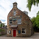
| Charlestown Of Aberlour, The Mash Tun Bar | 57°28′15″N 3°13′39″W / 57.470731°N 3.227422°W | Category C(S) | 49987 | 
| |||
| Queen's Road, Fleming Hall And Cottage Abutting Rear Gable | 57°28′11″N 3°13′25″W / 57.469663°N 3.223684°W | Category B | 20871 | 
| |||
| Craigellachie, John Street, Primary School And Front Railings | 57°29′24″N 3°11′08″W / 57.489953°N 3.185443°W | Category B | 2355 | 
|
Key
[edit]The scheme for classifying buildings in Scotland is:
- Category A: "buildings of national or international importance, either architectural or historic; or fine, little-altered examples of some particular period, style or building type."[1]
- Category B: "buildings of regional or more than local importance; or major examples of some particular period, style or building type, which may have been altered."[1]
- Category C: "buildings of local importance; lesser examples of any period, style, or building type, as originally constructed or moderately altered; and simple traditional buildings which group well with other listed buildings."[1]
In March 2016 there were 47,288 listed buildings in Scotland. Of these, 8% were Category A, and 50% were Category B, with the remaining 42% being Category C.[2]
See also
[edit]Notes
[edit]- ^ Sometimes known as OSGB36, the grid reference (where provided) is based on the British national grid reference system used by the Ordnance Survey.
• "Guide to National Grid". Ordnance Survey. Retrieved 12 December 2007.
• "Get-a-map". Ordnance Survey. Retrieved 17 December 2007. - ^ Historic Environment Scotland assign a unique alphanumeric identifier to each designated site in Scotland, for listed buildings this always begins with "LB", for example "LB12345".
References
[edit]- All entries, addresses and coordinates are based on data from Historic Scotland. This data falls under the Open Government Licence
- ^ a b c "What is Listing?". Historic Environment Scotland. Retrieved 29 May 2018.
- ^ Scotland's Historic Environment Audit 2016 (PDF). Historic Environment Scotland and the Built Environment Forum Scotland. pp. 15–16. Retrieved 29 May 2018.
